
 by Amy DeMuth
As winter days lengthen into spring, nothing ushers in the new season like an ample dose of sunshine, a big breath of fresh air and a ramble among the company of nature. Carson Valley offers hikers and nature lovers a vast array of terrain, biological zones and elevations for spring hikes that are full of diverse blooming flora.
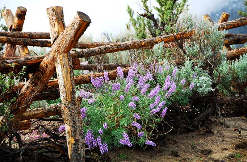
With the Sierra Nevada range to the west and the Great Basin to the east, Northern Nevada’s most scenic valley is situated in an ecological transition. From subalpine zones on the west slopes to wetland and floodplains below, then eastward to the interior chaparral and semi-desert ecoregions, Carson Valley is rich in all types of wildflowers. Spring hikers may be lucky to spot the rare Carson Valley monkeyflower which grows exclusively in Carson and Washoe Valleys.
Carson Valley is guarded on the west by rugged 10,000 foot peaks and sees nearly 300 days of sunshine per year. Pleasant weather, bluebird skies and miles of open space await spring hikers. Carson Valley is comprised of the four communities of Minden, Gardnerville, Genoa and Topaz Lake. Throughout the region, more than 54 miles of maintained multi-use trails provide hiking options for all abilities, each with a distinct setting and habitat. As high alpine shifts to high desert, visitors can hike among a diverse bloom of trees, shrubs, cacti and wildflowers.
Fay Luther Jobs Peak Ranch Trail System:
This trail system connects Fay-Luther and Jobs Peak Ranch Trailheads and is situated on the western slope of the Carson Range, with Jobs Peak towering above. At 10,633 feet in elevation,

Jobs Peak is the most prominent peak visible from Carson Valley and is often glistening with snowpack. Despite the views, the 9 miles of loop and connector trails in this system are fairly gentle. The trail system includes an interpretive loop with signs about the area. For more information on this trail system, directions and to view a trail map, please visit online.
The Fay Luther Job Peak Ranch Trail System and other westside trails present a mix of Great Basin and Sierra Nevada plant species. There is more rainfall here and the soils are sandy with granite. Some of the most notable blooms along this trail system include greenleaf manzanita, threadleaf phacelia, prickly poppy, annual mitra, steamboat monkey flower, trailcup lupine and desert peach. From the trails, hikers can also spot the beautiful blooms of dwarf suncups, antelope bitterbrush, snowbrush, blue eyed Mary, mustang mint, blue elderberry, snowplant, Sierra onion, mountain alder and redstem miners lettuce.
Clear Creek:
The Clear Creek trail is another westslope trail, situated in the north of Carson Valley. Clear Creek trail is a 15 mile adventure that switchbacks up the Carson Range, initiating at the valley floor and climbing to the Tahoe Rim Trail.

Once the snowpack has melted, hikers can reach Spooner Summit where spectacular views of both Carson Valley and the Lake Tahoe Basin can be found. For more information on the Clear Creek trail, directions and to view a trail map, please visit online.
Clear Creek Trail covers an impressive elevation gain and rewards hikers with blooms of purples, whites, pinks and yellows. The rare Carson Valley monkeyflower, mini monkeyflower and Washoe Phacelia can be spotted in the spring. Hikers can also see flowering tidy tips, clustered broomrape, humble phacelia, western peony, sand cryptantha, white cornsalad, mule ears, desert bitterbrush and desert peach.
Pinyon Trail:
The Pinyon Trail is a 5 mile round trip hike located on the eastside of Carson Valley, approximately 7 miles east of Gardnerville. The Pinyon Trail is situated at an elevation that does not see much snow and is a great moderate year-round option. The season’s first wildflowers can be seen from this trail where temperatures will begin to warm up earlier than in higher elevations.

Wonderful views can also be spotted, with the Sierra Nevada and Carson Valley to the west, and the Pinenut Mountains to the east and south. For more information on the Pinyon Trail, directions and to view a trail map, please visit online.
The Pinyon Trail is in Carson Valley’s high desert biological zone, where there is less precipitation and the soil is comprised of limestone and clay. As such, the ecosystem here supports a much different diversity of wildflowers. The trail’s most photogenic wildflowers include Anderson larkspur, sego lily, arrowleaf balsamroot and golden violet. Nevada biscuitroot, desert strawberry, shaggy milkvetch, purple sage, sticky yellowthroats, princess plume, Lavin eggvetch and smooth horsebrush can be spotted.
River Fork Ranch Trail System:
For hikers that visit Carson Valley later in spring, the River Fork Ranch Trail System provides a wonderful opportunity to view wetland flora that bloom later in the year. The River Fork Ranch Trail System is one mile east of Genoa and sits at the confluence of the East and West Fork of the Carson River. There are two relatively easy interpretive trail loops, the 0.75 mile East Brockliss Loop and the 2.0 mile West Fork Trail. For more information on the River Fork Ranch Trail System, directions and to view a trail map, please visit online.
River Fork Ranch is an 800 acre preserve owned and operated by the Nature Conservancy.
The preserve is both a working ranch and a riparian corridor where pastures, meadows and wetlands support a robust and diverse wildlife population including bald eagles, sandhill cranes, leopard frogs, monarch butterflies and mule deer.

When not being amazed by the abundant wildlife, visitors to the River Fork Ranch Trail System can find Wood’s rose, golden currants and rose hips blooming in the spring. As the summer approaches, these trails blooms of blanket flower, snow milkweed and narrow leaf milkweed. For more information about River Fork Ranch, please visit the Nature Conservancy online.
Carson Valley is less than 45 miles from the Reno-Tahoe International Airport, 30 minutes from Lake Tahoe and 20 minutes from Carson City. The region boasts plenty of accommodation choices, from hotels to motels and casinos to hot spring resorts. For more on where to stay, visit online.
The trails in Carson Valley are maintained by the Carson Valley Trails Association, a non-profit volunteer based organization working with partners to provide public access through a recreational trail system for present and future generations to enjoy.
For more information on the spring wildflower season in Carson Valley, visit online. A wildflower sampler, courtesy of Carson Valley Trails, can be found online.
About Carson Valley:
Nestled at the base of the Sierra, Carson Valley begs visitors to not just drive through it, but to it. Located 45 miles south of Reno-Tahoe International Airport and 12 miles east of South Lake Tahoe, the region’s natural beauty is legendary: wide-open farms, ranches, bands of wild horses and birds of prey dot the landscape. Outdoor recreation enthusiasts follow all points of the compass with more than 50+ miles of hiking, mountain biking or walking trails along with world class road biking. The valley’s museums, arts, antiquing, Basque dining, historic watering holes and more add to the destination’s authentic culture. The region includes the communities of Minden, Gardnerville, Topaz Lake and Genoa, Nevada’s first settlement dating back to 1851. Explore the land of everyday legends at VisitCarsonValley.org.
###


